The Road Connecting Past and Present

The King’s Road (Le Chemin du Roy)

« I travelled in a carriage last August from Montreal to Quebec City in four and a half days. »
– Chief Road Officer Lanouiller de Boisclerc, 1735

In the early 18th century, roads in New France were scarce and poorly developed. There were a few paths, but none connected Quebec City to Montreal. In 1706, authorities decided to build a road along the river where the first settlements were located.

Text credit: Christian Morissonneau, historian and professor, Department of Humanities, Université du Québec à Trois-Rivières.

The Birth of a Landmark Route

In the early 18th century, New France had only a small road network. Although some scattered routes and roads existed, none connected Quebec City to Montreal. In 1706, the Superior Council decided to build a road along the St. Lawrence River.

Thanks to the “King’s chores”, Chief Road Officer Eustache Lanouiller de Boisclerc undertook massive construction work from 1731 to 1737:

  • 280 kilometres long
  • 7.4 metres wide
  • 37 seigneuries crossed

The Longest Road North of the Rio Grande

For over 150 years, the King’s Road was used for mail delivery by stagecoach and for travel by carriage, diligence (horse-drawn carriage for public transport) and carriole. Up to 29 relay stations were set up for stops, including Berthier for lunch, Trois-Rivières for an overnight stay and Deschambault for another meal stop. With horses, the journey could be completed in just two days.

Today, much of Route 138 follows the historic path of the Chemin du Roy, from Quebec City to Repentigny, passing through Trois-Rivières.

1663
The Birth of a Royal Province

In 1663, New France became a royal province, with a governor accountable to the king. That same year, the deployment of the Carignan-Salières Regiment marked a turning point in protecting trade and settlements from the Iroquois threat.

After a somewhat successful incursion into what is now New York State, several officers and soldiers decided to stay in New France, helping establish new colonies. By 1672, Intendant Talon was granting land to these soldiers, so that by 1681, the population had nearly reached 10,000 people.

Over time, the colony received livestock – especially horses, which played a crucial role in clearing land. Beyond agriculture, horses were also used for land transportation, which remained underdeveloped for a long time compared to river transport, which was impassable in winter.

1660s
The First Roadsof New France

The first roads of New France appeared in the 1660s, between Cap-Rouge and Cap-Tourmente. Often rudimentary, these roads mainly connected villages to Quebec City, the administrative and religious capital of the colony. The seigneuries were responsible for maintaining paths that were sometimes more like trails than actual roads. Known as “chemins de grèves” (pebble roads), they followed the shoreline, were traced by usage and were not continuous from one town to the next.

Between 1709 and 1713, a road was opened between Lévis and the Rivière-du-Loup seigneury, linking Quebec City to more distant territories. The roughly 150 km route connected to a portage trail leading to Acadia, running between the St. Lawrence River and the Saint John River via Lake Témiscouata.

In 1665, Governor Courcelle had a road built between Longueuil and Chambly to facilitate the movement of French troops from Montreal to Iroquois territory. However, the link between La Prairie and Saint-Jean was only completed in 1748. The Quebec-Montreal route along the south shore was not fully completed until after the Conquest.

The Role of the Chief Road Officerin the King’s Road

Appointed by the Intendant, the chief road officer, also known as Grand Voyer, was responsible for roadworks in New France. This title was first granted in 1657 by the Compagnie des Cent-Associés to René Robineau de Bécancour. The Baron of Portneuf enjoyed his title without actually taking care of the roads. It was only on February 1, 1706, that the Superior Council of New France officially defined his responsibilities, coinciding with the construction of major roads, including the one from Quebec City to Montreal.

The Grand Voyer was responsible for supervising the construction and maintenance of roads but had no dedicated workforce. Instead, the inhabitants carried out the work. The corvée system was applied, where each tenant who owned land along the road was responsible for maintaining their section. Despite these efforts, roads were often muddy and impassable after bad weather.

After the death of René Robineau de Bécancour in 1699, his son, Pierre Robineau de Bécancour, inherited the position and began sketching out the royal road between Quebec City and Montreal, though he never completed it. He passed away in 1729.

Lanouiller de Boiscler: The Builder of the Chemin du Roy

Appointed Grand Voyer in 1731, Jean-Eustache Lanouiller de Boiscler stood out for his efficiency. By 1732, he mobilized the inhabitants to maintain the roads and brought to fruition a project that had been 30 years in the making: a flood-proof road along Lake Saint-Pierre.

By 1735, the road was advanced enough that he could travel from Montreal to Quebec City by post-chaise in just four and a half days. His legacy endures, as segments of the original route still exist between Yamachiche and Maskinongé.

A General Corvée
Who Was Involved in Road Construction?

Road construction in New France was based on the corvée (chore) system, a mandatory community labour duty. The Intendant entrusted roadworks to the Grand Voyer, who planned and inspected the roads, while militia captains oversaw the work in each seigneury.

Inhabitants had to provide part of their land and actively participate in building roads and bridges. The work was divided proportionally based on land ownership, and even seigneurs contributed. The general corvée aimed to maintain roads, secure river crossings and connect communities.

A Pivotal Shift
From Land Grants to Expropriation

Before 1729, road construction progressed slowly. Interventions by the Grand Voyer Bécancour were rare, and residents often contested the route by cultivating directly on the tracks, barely leaving room for a cart on the road. Despite resistance and neglect, construction of the Chemin du Roy accelerated with the arrival of Intendant Gilles Hocquart.

Upon his appointment in 1731, Jean-Eustache Lanouiller de Boiscler enforced a drastic change by strictly applying regulations. At the time, expropriation did not exist, but concession contracts included an obligation to cede space for roads, resulting in an explosion of ordinances and interventions by the authorities.

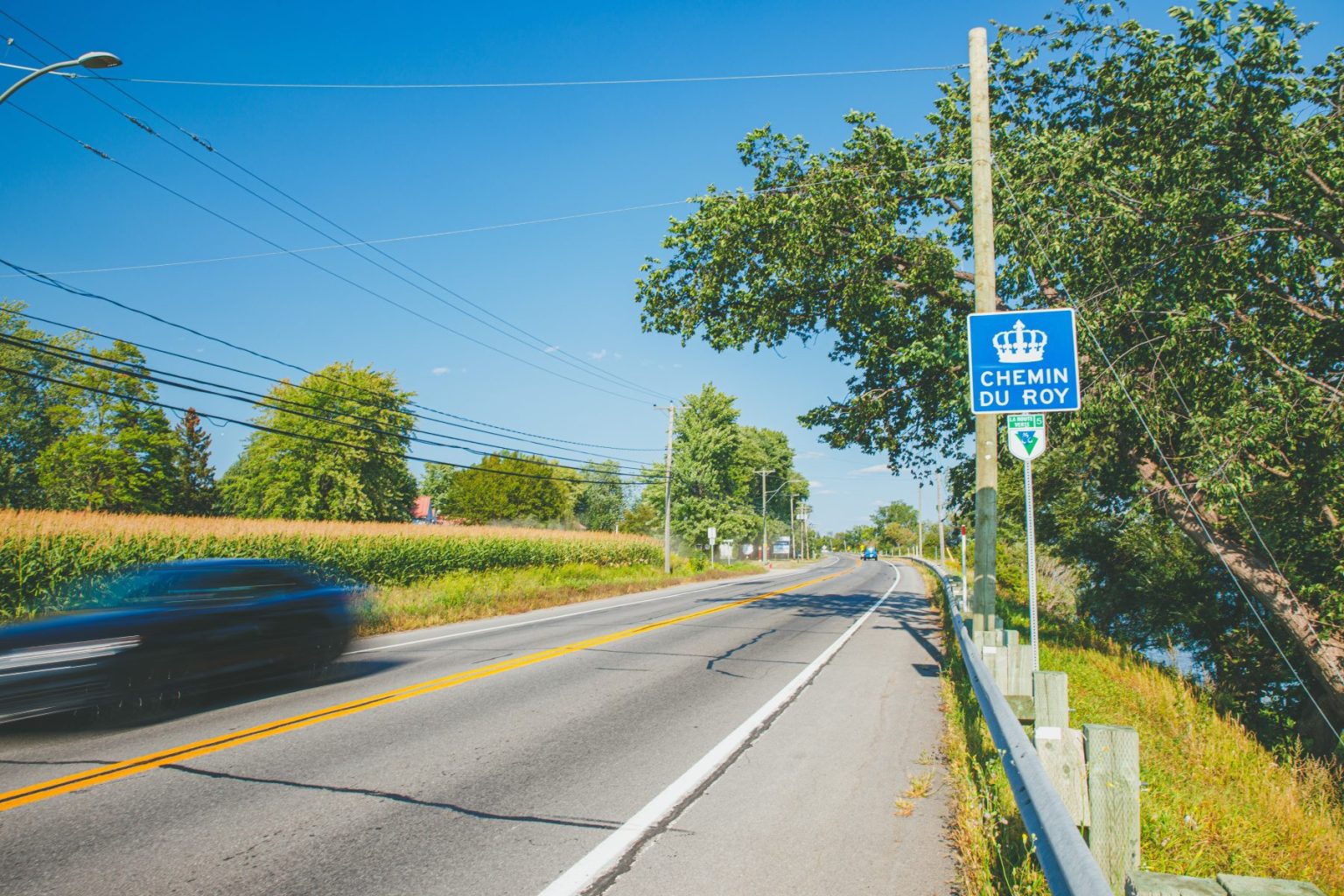
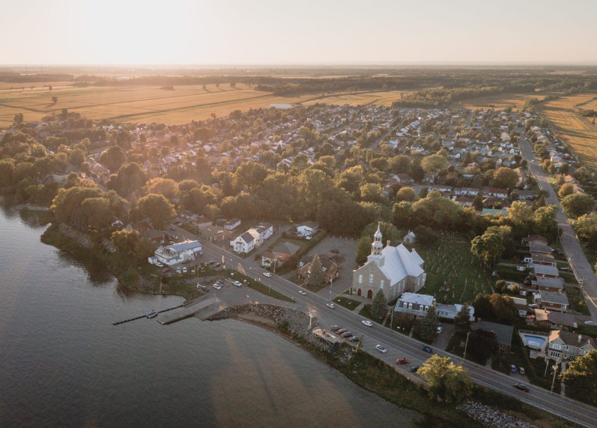
4 to 6 Days from Quebec City to Montreal

Before the King’s Road, only 14 of the 37 seigneuries between Quebec City and Montreal had usable road sections and no routes connected the estates to each other. By 1735, all seigneuries finally had their own road segments. The following two years were dedicated to building bridges and ferries, which were essential to ensuring the road’s continuity.

Historian Roland Sanfaçon highlighted the scale of the work achieved: in just seven years, the corvée system made it possible to build the first royal road between Quebec City and Montreal. This challenge was met despite harsh conditions and limited infrastructure.

In the 1730s, the Chemin du Roy became the longest developed road north of the Rio Grande. By comparison, the United States would not have an equivalent until 1806, with the National Road linking Maryland to Ohio.

The Beginnings of Public Transportation

The Post Chaise

The post chaise, later known as the calèche, was a lightweight, horse-drawn vehicle ideal for long-distance travel on uneven roads. This two-wheeled, open carriage was used for public transportation. Its winter counterpart, the carriole, was designed for travel on snow and ice with the aid of runners.

The Post Relay

As soon as the King’s Road opened, a network of post relays was established every 15 km or so, wherever a small village existed, to support passenger transportation. Each relay, run by a postmaster, provided essential continuity for land transport along the entire route. By 1767, post relays were subject to the same laws as those in England, granting postmasters a monopoly on horses and vehicles.

From the Calèche to the Stagecoach

In 1780, an ordinance officially regulated the 24, then 29 relay stations and public transportation. Each postmaster was required to provide calèches (carriages) within 15 minutes. At that time, the roads between Quebec City and Montreal, as well as between Montreal and Saint-Jean, were the only true postal routes. By 1811, the carriages were phased out in favour of stagecoaches for public transportation.

As early as the 1760s, express mail connected Quebec City and Montreal in 30 hours, but demand quickly grew. In 1792, a postal convention led to the creation of Quebec’s first postal stagecoaches, carrying both mail and passengers. By 1799, a mail coach ran between Quebec City and Montreal once a week.

The First Stagecoaches

In 1792, the first public carriages, called “stages” by English speakers, began operating. The term “stagecoach” appeared in 1808. Throughout the 19th century, both “stage” and “stagecoach” were used interchangeably for these relay vehicles. The term “mail coach” (malle-poste), referring to a postal stagecoach, was less common.

Stagecoach, Mail Coach or Steamboat?

In the 1810s, stagecoaches carried more and more passengers, while steamboats became popular around 1815. However, it was only in the 1840s that steamboats began transporting mail. People could choose between postal service by land or by boat.

Mail service by mail coach operated year-round, whereas steamboats bypassed most riverside villages in the summer, stopping only at Sorel, Port-Saint-François and Trois-Rivières. In winter, travelers had to choose between the faster mail coach and the regular stagecoach. The journey from Quebec City to Montreal took between 34 and 36 hours.

Between 1810 and 1850, the number of stagecoach stops was reduced to ten stations – compared with some thirty for carriages – amid fierce competition between Samuel Hough’s Red Line and Michel Gauvin’s Green Line. Each was named for the colour of its owner’s vehicle. The two companies, one serving Canadians, the other English, joined forces in 1844, leaving only a single winter stagecoach service on the King’s Road.

Berthier, located halfway between Montreal and Trois-Rivières, was a key stop for travelers. With over 20 inns recorded in the 1820s, it was a popular midday meal stop, making it an essential rest point.

The Train: A New Competitor

Starting in the 1850s, railroads became a major competitor to road transportation. In 1854, the opening of the railway between Lévis and Richmond, which connected to the Grand Trunk Railway toward Montreal, led to the decline of stagecoach travel. Only the mail coach continued transporting mail and passengers year-round.

In 1879, the railway on the north shore of the river put an end to the mail coach service between Quebec City and Montreal, marking the end of public horse-drawn carriage transportation.